Continuing along in this new series devoted to the best looking boards found in the wargaming world where every other Friday, I will highlight the art and layout of a different board in a wargame that we have played to show you the various talents of the artists and graphic designers involved. In my humble opinion, a well designed and attractive board can make all the difference in the world to me enjoying a wargame. Don’t get me wrong, the game has to be good, but if it’s also good looking it always is a better experience. A board can draw me in. Can make me feel that I’m there. Can set the stage for the thematic immersion that we all crave. And I have found many of these type of boards and I want to make sure that I share them with you.
Nicolas Roblin is a new and emerging artist who has four game boards to his credit, and each of the four games we have played and really enjoyed. Including This War Without an Enemy (2020), his credits also include 300: Earth and Water from Nuts! Publishing (2018), Saladin (2022) and Border States (2022) both from Shakos. He has a very easy style that is focused on showing the locations in a light that emphasizes their importance to the historical story that the game designer is attempting to tell. What I mean by that will be evident as we take a look at This War Without an Enemy, but one thing I would point out is the focus on the boundaries of the two sides’ holdings as well as the size and relative opulence and grandeur of the various cities, towns and villages represented on the board. Some of these are key locations, while others are not as important and you can tell that by the way he draws them. Some of it has to do with population, size and overall features but he also gives the locations their own character which is pretty interesting.
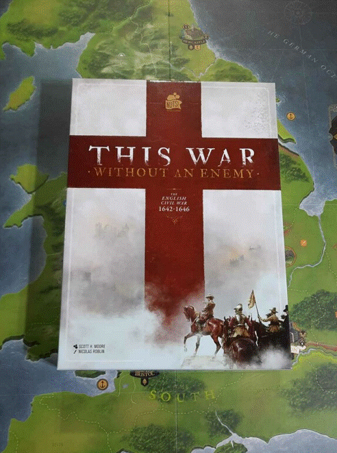
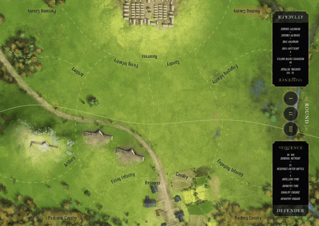
This War Without an Enemy: The English Civil War 1642-1646 is a 2-player strategic block wargame, that covers the First English Civil War, when the Royalist forces fighting for King Charles I were opposed by the English Parliamentarian troops and their Scottish allies, the Covenanters, in a struggle for political, economic and religious control of England. This struggle was over who would lead the country and was bitterly fought. I think that the choice of the title is also very appropriate as this was fought between the English. Brother against brother, family against family, neighbor against neighbor. Very similar to the US Civil War and was a fight over ideology. There was no external force invading the country and trying to enslave or destroy the English. This was a disintegration of the ability to compromise and work together. The game focuses on lots of aspects as it is a card driven game, but combat is a big part of what the game does and this is given its own Battle Board, which is also very well designed and illustrated if not a bit small.
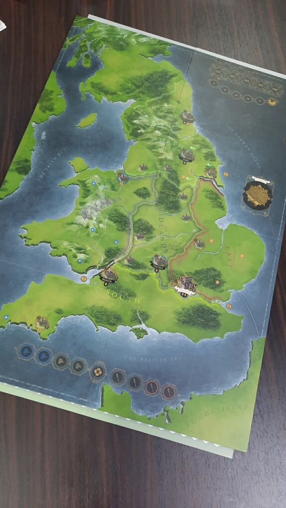
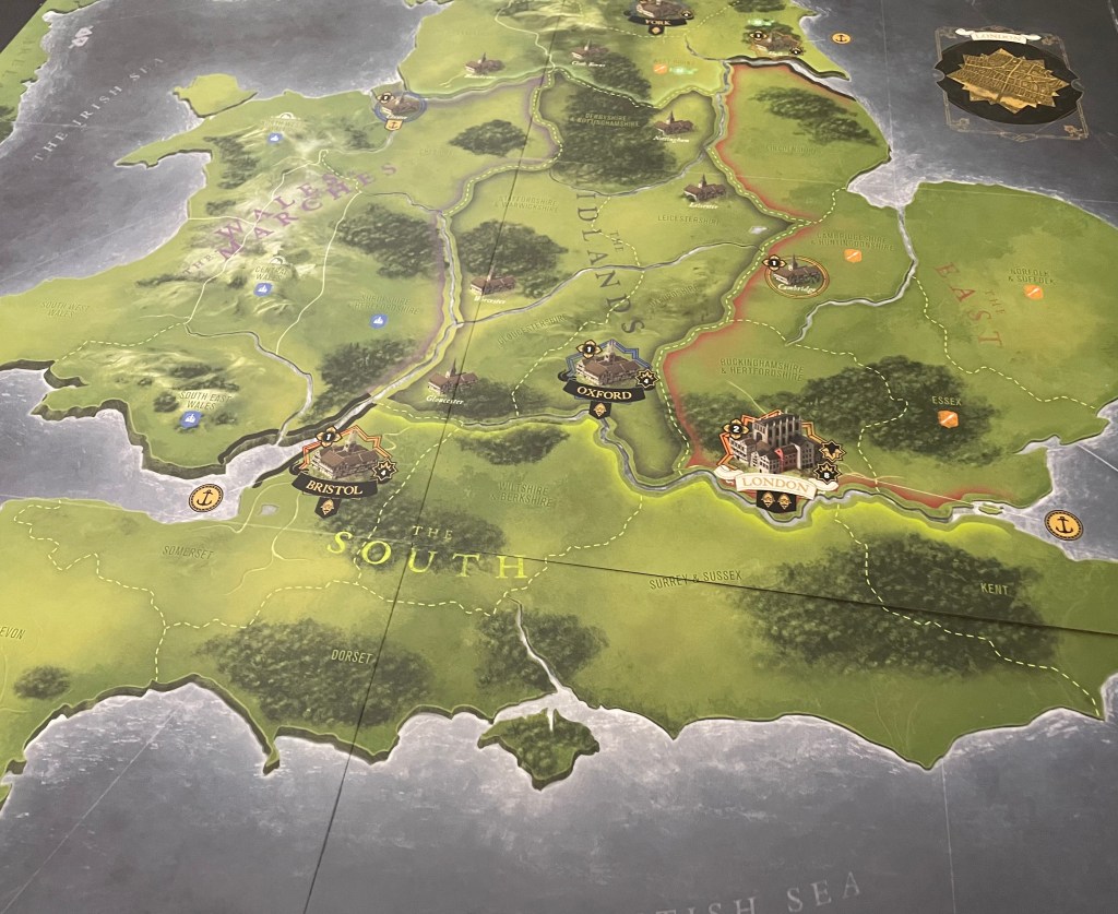
The board includes the entirety of lower, central and northern England, Wales, Scotland and shows parts of Le Continent (France) and Ireland as well. But the action takes place only in the bounds of England proper and Wales and no units are allowed to enter France, Scotland or Ireland although some units will start in Ireland and Scotland. This is a local fight and the board focuses on this. The board also uses area movement and different areas are sectioned off using dotted lines that are very clearly seen on the board. The green backdrop of the grassy land aids in these lines being easily recognizable.
It is important to take note immediately that there are really 3 different areas represented here on the board that are all tied to their allegiance or lack of to one side of the conflict or the other. On the east side of the island are the Parliamentarians (orange) and their holdings as they control the East, which includes Norfolk & Suffolk, Lincolnshire, Cambridgeshire & Huntingdon Shire, Buckinghamshire & Hertfordshire and Essex. This area has a Region boundary that is colored red for easy identification and to separate the 3 areas. You will also notice areas marked with a blue crown icon are loyal to the Royalists, while those marked with an orange mace icon are Loyal to the Parliamentarians.
The areas that don’t contain any of these specific symbols are not directly aligned with or favoring either of the two protagonist sides. This is considered to be neutral territory and in essence turns into a sort of “No Man’s Land” due to the fact that most of the key battles between the two warring sides will be fought in this neutral area first, churning up the ground and turning it into a blood soaked terrain that is devoid of any semblance of its former state. Remember, that there are blocks from both sides set up at the outset of the game in this neutral area. Once these initial battles are fought and won, and ground is gained or lost, the players will have a bit more freedom to maneuver around the board to find new areas to control and take from their enemy. The game cannot end in a stale mate as players will be pressing against their enemy’s territory to try and take the crown for themselves.
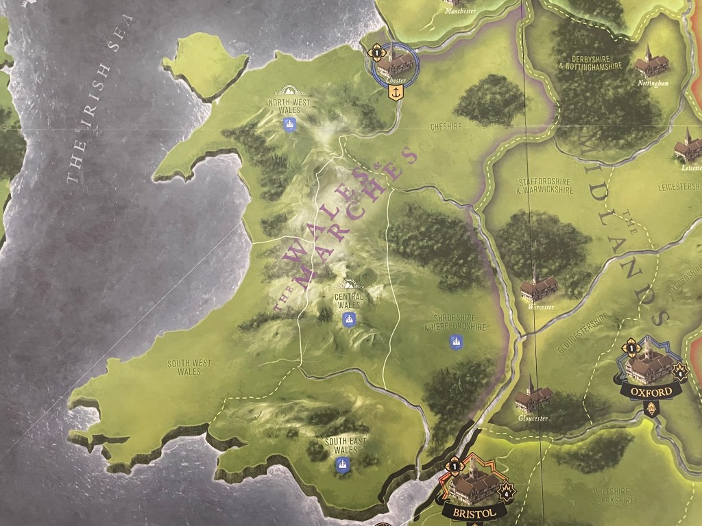
The Royalists (blue) are found in the western part of England and their holdings include Southwest Wales, Central Wales, Northwest Wales, Southeast Wales, Shropshire & Herefordshire and Cheshire. These holdings have a Region boundary that is colored light gray. Each side does have some additional influence in other areas as the starting setup places blocks in certain areas not clearly aligned with either side.
The remainder of the other areas are not controlled by either side but are considered neutral and appear to be somewhat of a battle ground area as there are large formations of both sides blocks found in this Region at the start of many of the scenarios. Some of the cities in these neutral areas have a blue or orange circle around the city which shows that they are leaning toward that side.
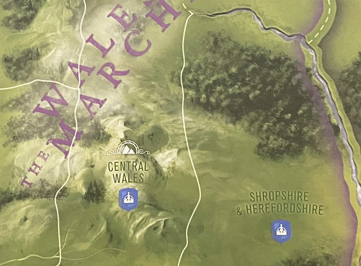
The mountainous areas include a special icon of a mountain on them. There are only two of these areas, including one in Wales and the other in the North that encompass the areas of Cumberland & Westmorland, NW Wales and Central Wales. These icons are important as these areas will provide reduced supply to the players and you must prepare for this. The mountains are also very beautiful as they have a misty overlay on top of them obscuring the full view of each of the mountain peaks. This white overlay really adds some interest to the mountains and I really appreciate that Nicolas used this technique.
The other really interesting aspect of the board involves the movement of units. The various geographic features including rivers (blue) or mountains (continuous white) borders, govern the maximum number of blocks that may cross the border when entering an Area to Attack or Reinforce or when leaving an Area to Retreat from a Battle. This is a rules choice that really highlights the terrain of the areas and makes the game that much more strategic as players will have to carefully consider their movements to ensure that they are able to field the proper units for combat. I really liked the way this was represented as it makes it clear when making movement choices. Impassable areas are shown in black and when they correspond with water, this means that the player must perform a Sea Move to get across that area.
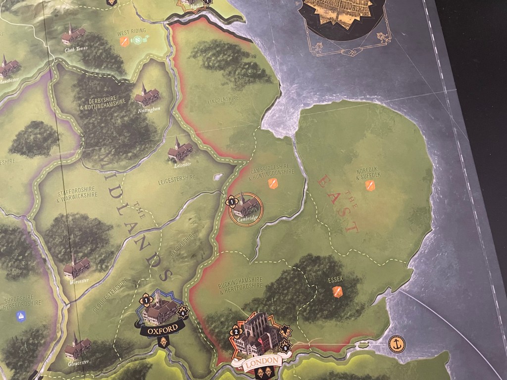
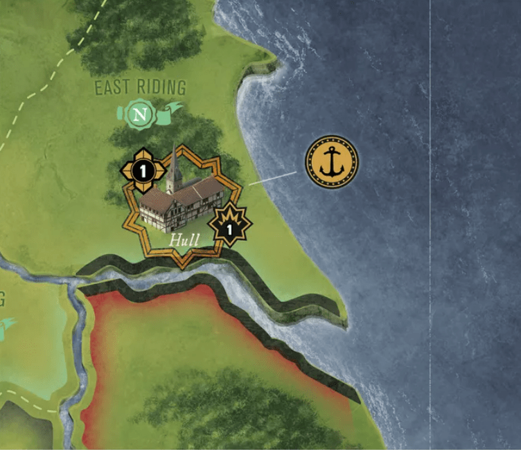
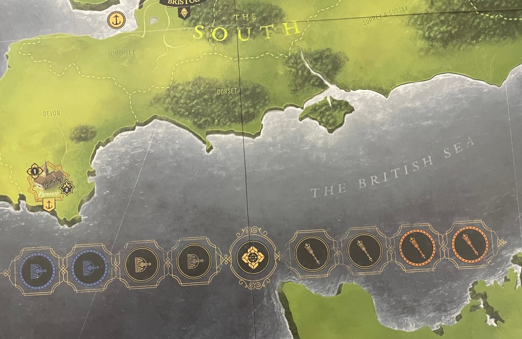
Now let’s take a closer look at some of the regions, and their really well done graphical touches to make them stand out. Sothern England, or The South as it is referred to on the board, is home to four large Major Cities including London, Oxford and Bristol and 1 Minor City in Plymouth.
Let’s take a closer look at Bristol. Bristol is a Major City and is fortified and you can tell both by the large black banner and title at the bottom of the city as well as the fortified wall shown around the buildings. If you look at Gloucester just to the north it has no banner and it is classified as a Minor City, the name of the city is smaller and there is no fortification built around the building. The other key with cities is that their allegiance is shown by a color around the outside. In the case of Bristol, the orange tells you that it is loyal to the Parliamentarians. It is very rare to see this kind of detail with cities on a wargame board but I really appreciate the aesthetic that it presents here. It works mainly due to the fact that the board uses area movement but I do like the attention to detail and it really makes the board stand out from other area movement boards we have played on.
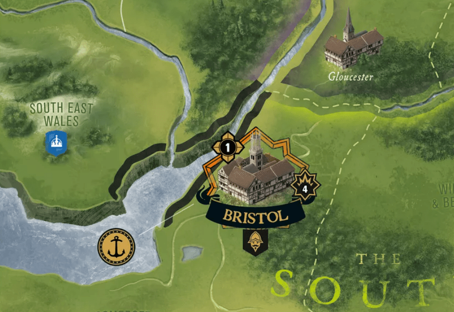
There are lots of other symbols and pieces shown on the cities including their Storm Value (in the bottom right), Victory Point Value (upper left) and under the banner is shown a face which equates to the City’s Recruitment Points. Fortified Cities can hold a number of blocks equal to their size, and can be Stormed by a number of blocks equal to the Storming Value. I really like the way that the cities are shown, with the different size buildings and their loyalties and whether they have fortifications or not. Their size also is very well done as upon looking at the map you immediately see the importance of certain cities as compared with others.
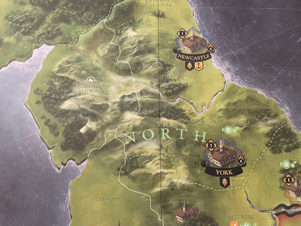
The North is again a striking example of the misty overlay used on top of the mountains but the part of this area of the mountains that I really find interesting is near York. I can see several different types of trees on this area of the mountains including deciduous and conifers. That level of detail is pretty interesting and really adds some depth to the immersion on the board. I also really like that the land itself is varying shades of green and also includes some black lines highlighting terrain shifts, including gullies and depressions.
One final element that I would like to look at is the treatment of the oceans. As the bodies of water come near to the shoreline, the water gains white highlighting representing white caps on waves. I love the motion and real life element that this conveys to the large bodies of water. It would have been easy to simply focus on the blue of the water but the extra effort has added a nice feeling of motion that once again assists the player in immersion.
The Battle Board is a separate piece from the main board and is used during combat. As you look at the Battle Board you will see that there are areas for each of the defending and attacking sides’ units and these are divided up by type to aid in the process of going through the battle process. I love the intricate details shown on the Battle Board including some elements of terrain, such as copse of trees, various fortifications, a lower, swampy area and the road cutting through the board from right to left. I also like the different sides situation as the defender side is shown with a town in the background and the attacker has an organized military encampment with tents setup for the invading army. The level of detail used in the board and its ancillary aids is just phenomenal and truly creates the appropriate feel for the game.
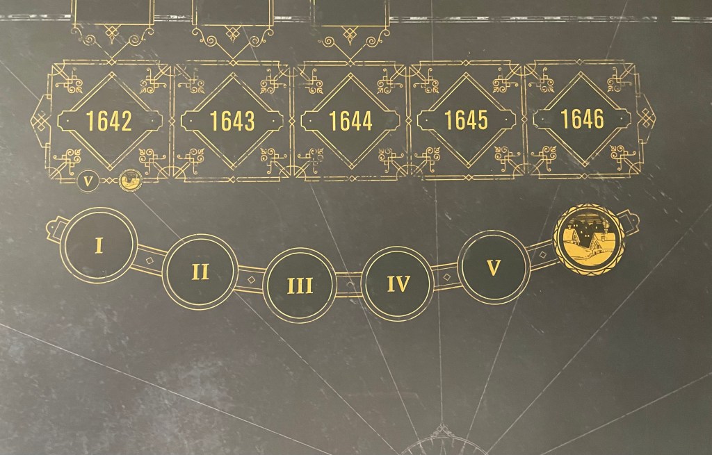
The Year and Turn Track are very well done and have the antiquity feel of writing style that was popular in this age adorning the various boxes and circles used to mark the passage of time. The lower track marks the various turns in a single year as there are 6, including the final space being a Winter Turn.
The Victory Track shows the relative number of Victory Points that each player has and it is a form of a pendulum as it can swing back and forth. The center position represents 0 VP’s, the positions with a crown icon show the VP’s for the Royalists and those with a mace icon show the VP’s for the Parliamentarians. If, during the Victory Phase at the end of any Turn, the marker is at 3 or more VP’s towards either side (shown by the orange or blue-colored icons), then the player controlling that side
has won the game. This Victory Track using the same symbols as are found on the board marking the ownership of areas is a very nice tie-in and brings it all together to help the player play the game without worrying so much about remember the where’s and what’s of each area as the symbols give quick reference.
This War Without an Enemy is a superb block wargame that creates a lot of tension as players will be duking it out regularly in this very interesting game. I feel that the use of blocks was inspired and really created the feel of being there and not knowing exactly what forces were arrayed against you causing you have to sometimes throw caution to the wind and charge into combat. The board in this game really aids in the creation of a thematic experience as well and was a perfect marriage with the subject.
Here is a look at our unboxing video for This War Without an Enemy: The English Civil War 1642-1646:
We also did a video preview for the Kickstarter campaign and you can watch that at the following link:
The next board that we will take a look at in the series is Holland ’44: Operation Market-Garden from GMT Games designed and illustrated by Mark Simonitch.
Here are links to the previous entries in the series:
Kekionga!: A Dark and Bloody Battleground, 1790 from High Flying Dice Games
Campaigns of 1777 in Strategy & Tactics Magazine #316 from Decision Games
Battle Hymn Volume 1: Gettysburg and Pea Ridge from Compass Games
From Salerno to Rome: World War II – The Italian Campaign, 1943-1944 from Dissimula Edizioni
-Grant
